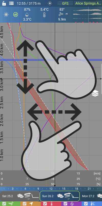
The graph shows depending on height and time:
- wind force
- direction of the wind
- the temperature
- relative humidity
- dew point
- a line of equal specific air humidity
- unsaturated adiabat
next:
- horizontal condensation level CCL
- horizontal isotherm for a temperature of 0°C
You can adjust the vertical range classically with two fingers from 1.5 km to approx. 12 km.
You can also classically use two fingers to adjust the horizontal range for temperature curves.
Individual curves can be turned on and off in the lower part.
The dew point is the temperature at which the moisture in the air begins to condense into liquid form, typically forming dew or fog. It is the temperature at which the air becomes saturated with water vapor and can no longer hold all of the moisture it contains.
The dew point depends on the amount of water vapor in the air and the temperature. Higher water vapor content or lower temperatures result in a lower dew point. When the air temperature approaches the dew point, condensation occurs on cool surfaces, resulting in the formation of dew.
The dew point is an important factor in meteorology and is used to predict the occurrence of fog, precipitation, and other weather phenomena. The study of dew and dew-related phenomena involves the examination of the interaction between air humidity, temperature, and condensation nuclei that facilitate the formation of water droplets.
The zero isotherm of temperature refers to the temperature at which air cools down to the point where water undergoes a phase transition from a liquid state to a solid state (ice). More specifically, it is the temperature at which the amount of water vapor in the atmosphere is such that it can start condensing and transforming into ice.
At the zero isotherm of temperature, the air temperature approaches freezing point and undergoes significant cooling. Water in the atmosphere begins to condense and form clouds or falls in the form of snow or freezing rain if there is sufficient moisture. The zero isotherm of temperature is often associated with the arrival or proximity of a cold front, which is the boundary between cold and warm air masses.
The unsaturated adiabatic lapse rate, also known as the dry adiabat, refers to the rate at which the temperature of an unsaturated parcel of air changes as it rises or descends in the atmosphere without exchanging heat with its surroundings (adiabatic process) and without condensation or evaporation of water vapor.
When an unsaturated parcel of air rises, it expands due to decreasing atmospheric pressure. As the air expands, it cools at a rate known as the unsaturated adiabatic lapse rate. This cooling is primarily governed by the ideal gas law, which states that as the volume of a gas increases, its temperature decreases.
The unsaturated adiabatic lapse rate is approximately 9.8 degrees Celsius per kilometer (or 5.4 degrees Fahrenheit per 1,000 feet). However, this rate can vary depending on various atmospheric conditions such as moisture content and lapse rate changes with altitude.
It is important to note that the unsaturated adiabatic lapse rate applies to dry air parcels that do not contain enough moisture to reach the point of condensation. Once the air parcel becomes saturated and condensation begins, the adiabatic lapse rate changes to the saturated adiabatic lapse rate, taking into account the release of latent heat during condensation.
The convective condensation level (CCL) is the altitude in the atmosphere at which a rising parcel of air becomes saturated and condensation begins to occur due to the cooling of the air parcel as it expands. It is a significant parameter in meteorology and is used to estimate the base of convective clouds, such as cumulus clouds.
As the Earth's surface is heated by solar radiation, it warms the air in contact with it, causing the air to become buoyant and rise. As the air parcel rises, it expands due to decreasing atmospheric pressure, which leads to adiabatic cooling. The temperature of the rising air parcel decreases until it reaches the dew point temperature, which is the temperature at which the air becomes saturated and condensation occurs.
The convective condensation level is the altitude at which the rising air parcel reaches its dew point temperature and condensation begins. It represents the base of the convective cloud formation. The actual height of the CCL depends on various factors, including the initial temperature and moisture content of the air parcel, the environmental lapse rate (rate of temperature decrease with height), and the presence of any inversions or stable layers in the atmosphere.
Meteorologists use the CCL as an important indicator of atmospheric instability and the potential for convective cloud development and thunderstorm formation. It helps in forecasting and understanding severe weather events, as convective clouds play a crucial role in the formation of thunderstorms, heavy rainfall, and other convective phenomena.